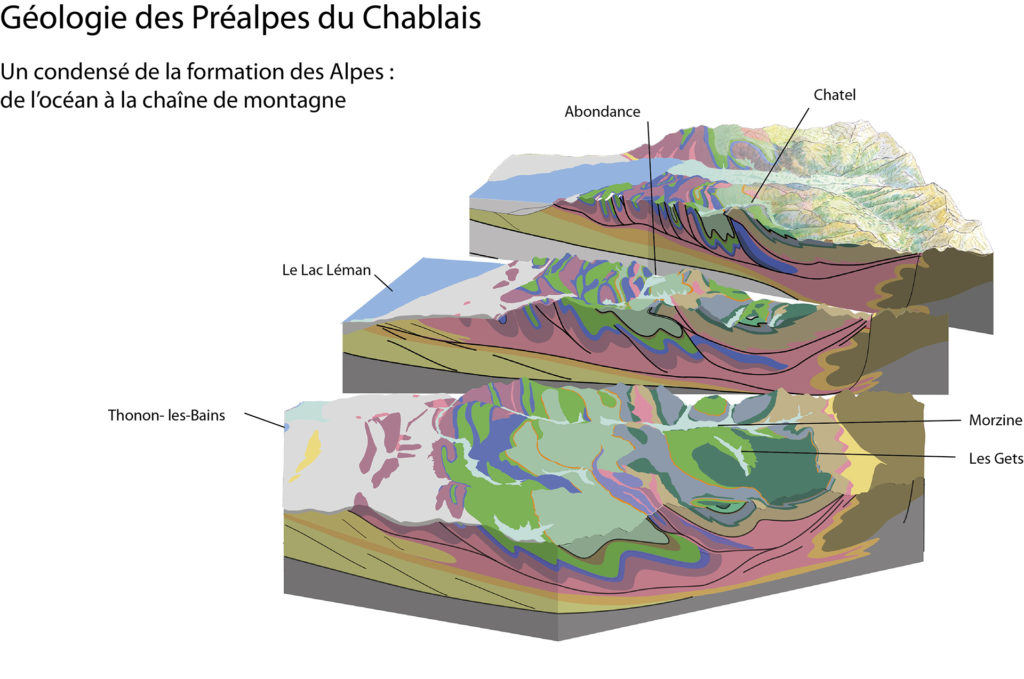


In the 50 km separating Thonon-les-Bains from Joux Plane pass (Morzine-Les Gets), the Chablais’ rocks reveal the history of the Alps’ formation. The Dranse de Morzine valley is a natural geological section, from the pillow lava in Les Gets (a vestige of the ancient Alpine Ocean) to Lake Geneva, which was created by the Rhône glacier. In this exceptional area, 245 million years of history are told.
A simplified geological history of the Chablais
The formation of the Chablais’ landscape began nearly 245 million years ago (mya). It can be broken down into 3 main acts: the formation of rocks, the formation of reliefs, and the shaping of landscapes by humans and erosion.
Act 1: the formation of rocks
Nearly 245 mya, at the beginning of the Mesozoic era, the Earth looked very different than it does today. The supercontinent Pangaea fragmented and a body of water — the Tethys Sea — emerged between what would become Europe and Africa.
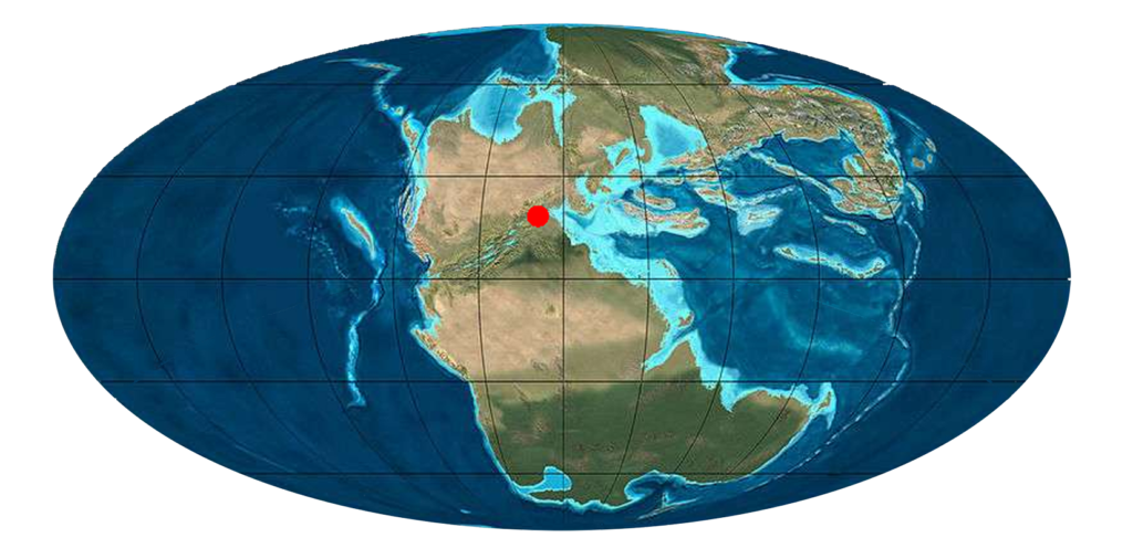
The red dot indicates the location of the Chablais rocks being formed during this period
During the Mesozoic era: the Triassic, Jurassic, and Cretaceous periods
During the entire Mesozoic era, the rocks in the Chablais Prealps were being formed in the Tethys Sea, which continued to expand. Even the two wide continental margins of Europe and Africa were underwater, without a single mountain on the horizon.

- The Triassic: a shallow Tethys Sea and a warm climate
In this sea that existed in the Triassic period (220 mya), “before the Alps”, the first shallow deposits were dolomites and gypsum. However, since the planet was undergoing a slow and constant transformation, the Tethys Sea first expanded through rifting between Europe and Africa.
- The Jurassic: expansion of the sea, rifting and opening of the Tethys Ocean
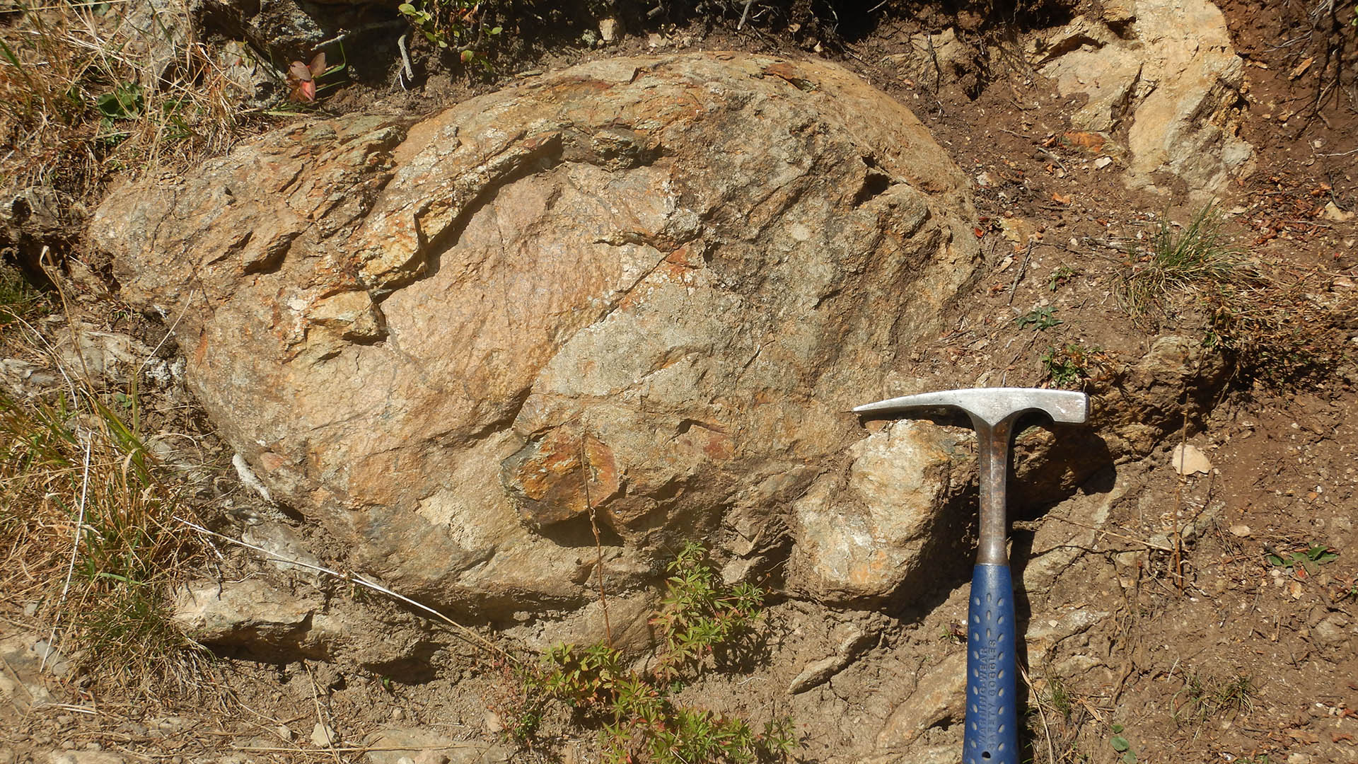
At the beginning of the Jurassic (Lias Period, 200 mya, then Dogger Period, 170 mya), earthquakes shook the two submerged continental borderlands: the cliffs (mainly dolomitic) collapsed in places, their debris settling to form breccia (coarse angular sediments).
During the Jurassic period, the sea became an ocean, in the middle of which continuous rifting created a mid-ocean ridge where basalt pillow lava spread out, which we can see today in Les Gets region.
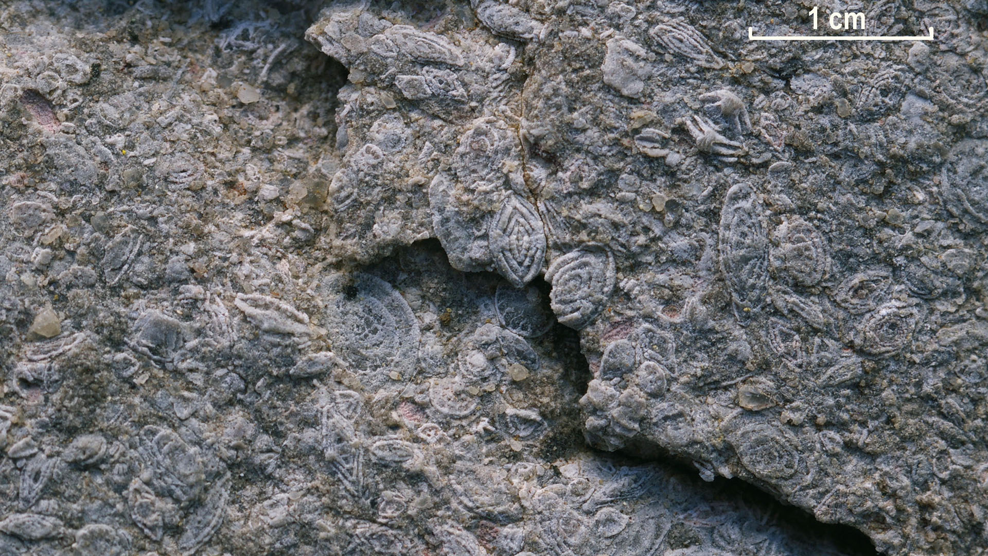
Towards the end of the Jurassic (the Malm Period, 150 to 140 mya), with clear water and a hot climate, large quantities of limestone were formed by chemical precipitation. These are the most visible rocks in the Prealps landscape: light-coloured and massive limestone that still form steep peaks with thick rocky ridges, such as the Dent d’Oche or the Pointe d’Ireuse.
- The Cretaceous: the beginning of oceanic closure
Significant changes occurred during the Cretaceous period. Global continental and oceanic drift brought Europe closer to Africa, and the Tethys narrowed again. A great deal of limestone and clay carried by rivers settled along the coasts. At the end of the Cretaceous (80 to 65 mya), in a tropical climate, red and muddy rivers flowing into the sea created the couches rouges (red limestones and marls) that can be seen in the Abondance, Aulps, and Brevon valleys.
In the Cenozoic era
At the beginning of the Cenozoic, during the Tertiary period, the Tethys had become much smaller, since a large part of the ocean had already sunk under Africa (via subduction). A sea remained on the borderlands of Europe where limestone was still being deposited, this time full of microfossils called nummulites. This nummulite limestone can be found in the Bostan region.
Act 2: the folding of the nappes
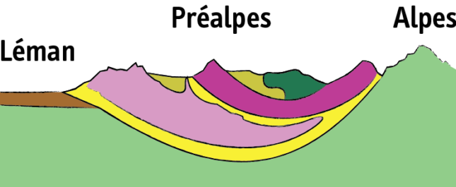
The mountains emerged principally during the Cenozoic era. Subduction continued and the European borderland of the Tethys was also pulled under the African plate: from 50 to 30 mya, marine sediments caught between the two continents were scraped off and deformed.
This “collision” led to stacking of the former sedimentation zones, with the southernmost areas piling on top of the northernmost ones. Despite this massive pile-up, the sets of rocks maintained their layers, which tilted and formed large mountain ranges.
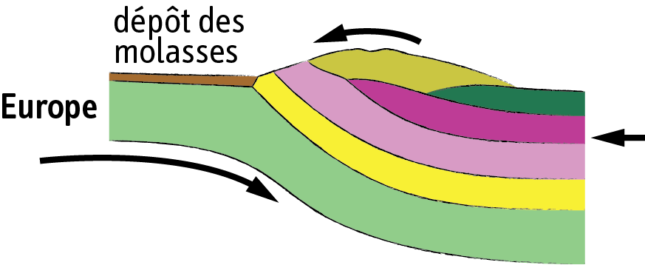
As a result, the rocks that formed in sedimentary zones located next to each other piled up on top of each other. They became what geologists call “nappes”, rock units that moved horizontally and vertically (see simplified diagram).
The limestones and marls of the European margin became the Morcles nappe (in light green, bottom of the diagram); the deposits of Briançonnais island became the Median Prealps nappes (light pink) and the sediments from its southern escarpment became the Breccia nappe (dark pink); the deposits from the bottom of the ocean became the Les Gets nappe (dark green) and those from the African borderland became the Upper of the Prealpines (apple green, top of the diagram).
On a smaller scale, this tectonic movement folded the layers, creating many faults and faults. Practically as soon as they formed, the Alps and Prealps (especially the upper layers) experienced erosion. These erosive deposits formed thick layers of sand and pebbles known as molasse, 30 to 20 million years ago.
Act 3: the shaping of the landscape through erosion
The end of this long history occurred during the Quaternary, in the last two million years. Glaciers sculpted the landscape, carving and widening the valleys, spreading out across France and the Swiss plateau, and forming lakes. The final touches were added by humans, the last to appear in this magnificent landscape.
The relief however continues to change its form, shaped by the joint actions of man and nature.